Brooklyn’s intersections pose significant risks to pedestrians and cyclists, with data indicating high accident rates at specific locations. Flatbush Avenue and Atlantic Avenue, Grand Army Plaza, and Broadway and Myrtle Avenue rank among the most perilous. Contributing factors include heavy traffic volumes, poorly designed layouts, and insufficient pedestrian infrastructure. These hazards necessitate urgent attention to enhance safety measures. Understanding the complexities of these intersections is vital in addressing the pressing issue of road safety.
Understanding the Factors Contributing to Dangerous Intersections
While the complexity of urban traffic systems can obscure the specific causes of danger, several key factors contribute greatly to hazardous intersections in Brooklyn. Urban design plays a pivotal role, with poor road layouts leading to driver confusion and increased accident risk. Narrow lanes, limited visibility, and inadequate pedestrian crossings exacerbate these dangers. Traffic management also influences safety outcomes. Ineffective signal timing and lack of synchronized lights result in congestion and unpredictable traffic flow, escalating the likelihood of collisions. In addition, high vehicle volumes, combined with insufficient infrastructure for cyclists and pedestrians, create perilous conditions. Data indicates that intersections with high accident rates often suffer from a combination of flawed urban design and suboptimal traffic management, necessitating targeted interventions to enhance safety.
The Intersection of Flatbush Avenue and Atlantic Avenue
The intersection of Flatbush Avenue and Atlantic Avenue stands out as one of the most perilous in Brooklyn, characterized by its high traffic volume and complex layout. Data from local traffic studies indicate that this intersection experiences frequent congestion, exacerbating risks for pedestrians and cyclists. The traffic signal timing, often misaligned with peak travel periods, contributes to confusion and increases the potential for accidents. Pedestrian crossings are particularly challenging, with multiple lanes of traffic and inadequate crossing times. This complexity requires vigilant behavioral adjustments from all road users. Additionally, the area’s proximity to commercial and transit hubs greatly increases foot traffic, compounding the dangers. Consequently, targeted interventions focusing on optimizing traffic flow and enhancing pedestrian safety are essential.
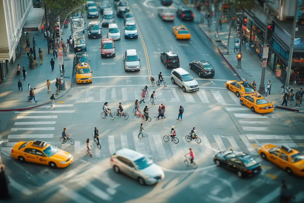
Navigating Grand Army Plaza: A Chaotic Convergence
Grand Army Plaza, a major traffic hub in Brooklyn, presents significant challenges due to its intricate traffic patterns, which involve multiple intersecting roads and a rotary system. Data indicates that these complex configurations contribute to increased congestion and a higher incidence of vehicular conflicts. Additionally, pedestrian safety is compromised, as studies show higher rates of pedestrian accidents compared to other intersections in the borough.
Complex Traffic Patterns
Maneuvering the intricate traffic patterns of Grand Army Plaza presents a formidable challenge for drivers, cyclists, and pedestrians alike. A confluence of six major roadways requires meticulous traffic signal timing and multi-modal integration to guarantee safety and efficiency. The complexity of this intersection is further illustrated by the diverse flow of vehicles, bicycles, and foot traffic.
| Traffic Element | Volume/Day | Average Delay (sec) |
|---|---|---|
| Vehicles | 84,000 | 47 |
| Cyclists | 2,500 | 19 |
| Pedestrians | 8,700 | 33 |
| Traffic Signals | 12 | – |
| Crosswalks | 10 | – |
Efficient navigation is hindered by inconsistent signal phases and fragmented cycling paths. Data shows that optimizing these factors could reduce congestion and improve safety. Coordinated efforts are crucial to harmonize the movement of all modes, minimizing potential conflicts at this critical juncture.
Pedestrian Safety Challenges
Maneuvering through the intricate traffic patterns of Grand Army Plaza underscores the considerable pedestrian safety challenges encountered at this bustling intersection. Data reveals high incident rates, largely attributed to inadequate pedestrian awareness and cyclist education. The convergence of multiple roads results in unpredictable vehicle movements, increasing the risk for those on foot and bicycles. Effective strategies demand enhanced signage and crosswalk visibility to alert both drivers and pedestrians. Research indicates that structured cyclist education programs could greatly reduce accidents, by informing cyclists of safe navigation practices in complex environments. Implementing advanced traffic control measures, including pedestrian countdown signals, could improve safety outcomes. The chaotic nature of Grand Army Plaza necessitates a multi-faceted approach to mitigate risks and enhance overall pedestrian safety.
The Perils of Broadway and Myrtle Avenue
At the intersection of Broadway and Myrtle Avenue in Brooklyn, the convergence of heavy pedestrian traffic, high vehicle volume, and complex traffic signals results in a hazardous environment. Data indicates that Broadway traffic is particularly dense, with vehicles often exceeding speed limits, contributing to collision risks. Analysis reveals that the intersection’s design inadequately addresses these issues, with a need for improved pedestrian crossings and clearer signal timing. Myrtle Avenue safety is compromised by frequent jaywalking incidents, exacerbated by insufficient pedestrian infrastructure. The intersection reports a high incidence of accidents involving both cyclists and pedestrians, underscoring the necessity for strategic intervention. Recommendations include enhanced signage, better lighting, and synchronized traffic lights to reduce confusion and improve overall safety outcomes in this critical urban junction.
The Hazardous Crossing at Fourth Avenue and Ninth Street
While Broadway and Myrtle Avenue present considerable challenges, Fourth Avenue and Ninth Street in Brooklyn emerge as another critical point requiring attention. Data indicates that this intersection experiences a high frequency of pedestrian and cyclist incidents. Several factors contribute to the hazardous conditions, including heavy vehicular traffic and complex traffic signal patterns. Inadequate cyclist awareness is noted, with cyclists often struggling to navigate the intersection safely. According to recent statistics, the area has recorded an increase in cycling accidents over the past year, highlighting the need for improved safety measures. Pedestrian crossings are poorly marked, exacerbating the risk for those attempting to cross. Addressing these issues through enhanced signage, better lighting, and dedicated bike lanes could mitigate these risks markedly.
Assessing the Risks at Bedford Avenue and Eastern Parkway
Despite Brooklyn’s myriad intersections, Bedford Avenue and Eastern Parkway stand out as a particularly concerning area for traffic safety analysts. The intersection is notorious for its high volume of pedestrian and cyclist traffic, coupled with complex traffic patterns that heighten the Bedford hazards. Data shows that pedestrian awareness is essential at this location, as the area frequently records incidents involving vehicles and vulnerable road users.
| Year | Pedestrian Incidents | Cyclist Incidents |
|---|---|---|
| 2020 | 15 | 9 |
| 2021 | 18 | 11 |
| 2022 | 22 | 14 |
The trend in the table highlights a worrying increase in incidents over recent years, underscoring the need for enhanced safety measures. Analyzing these statistics can help inform targeted interventions to mitigate risks at this critical Brooklyn junction.
The Challenges of the Kings Highway and Ocean Avenue Intersection
The intersection of Kings Highway and Ocean Avenue is characterized by significant traffic congestion, with an average daily vehicle count exceeding 40,000. Limited visibility further exacerbates safety concerns, as obstructed sightlines are frequently reported by drivers and pedestrians. These factors contribute to a higher incidence of accidents compared to other intersections in the borough, necessitating targeted interventions to enhance safety.
High Traffic Volume
Maneuvering the intersection of Kings Highway and Ocean Avenue poses significant challenges due to its high traffic volume. Data indicates that this intersection experiences one of the highest levels of traffic congestion in Brooklyn, with peak hours seeing an influx of both vehicular and pedestrian activity. The constant flow of vehicles complicates navigation for pedestrians, requiring heightened pedestrian awareness to safely cross. Studies show an average of 2,000 vehicles per hour during peak times, increasing the risk of accidents. The congestion not only delays commuters but also raises safety concerns, particularly for cyclists and pedestrians who must navigate amidst hurried drivers. The situation is exacerbated by the lack of adequate pedestrian crossings, highlighting a critical need for infrastructure improvement to enhance safety.
Limited Visibility Concerns
While traversing the intersection of Kings Highway and Ocean Avenue, limited visibility emerges as a significant concern for both drivers and pedestrians. Data indicates that the intersection’s design creates several visibility obstructions, including improperly placed signage, overgrown vegetation, and parked vehicles, which contribute to hazardous blind spots. Analysis of traffic incident reports reveals a correlation between these visibility issues and increased accident rates involving pedestrians and cyclists. The intersection’s infrastructure fails to accommodate the high density of road users, exacerbating the risk of collisions. Moreover, the obstructed sightlines hinder drivers’ ability to anticipate pedestrian movements, thereby increasing the likelihood of accidents. Addressing these visibility challenges is essential to improving safety measures and reducing pedestrian and cyclist vulnerability at this complex intersection.
Solutions to Enhance Safety at Dangerous Intersections
Addressing safety concerns at Brooklyn’s most hazardous intersections requires a multi-faceted approach informed by data and best practices. Traffic calming measures, such as speed bumps and reduced speed limits, can effectively decrease vehicle speeds, thereby enhancing pedestrian safety. Urban design modifications, including expanded sidewalks and pedestrian islands, improve visibility and reduce crossing distances. Data analysis and technology, such as timed pedestrian signals and sensor-based crosswalks, further optimize intersection management.
| Solution Type | Description |
|---|---|
| Traffic Calming | Speed bumps, reduced speed limits |
| Urban Design | Expanded sidewalks, pedestrian islands |
| Data Analysis | Timed pedestrian signals |
| Technology | Sensor-based crosswalks |
Implementing these interventions at the most dangerous intersections will likely result in a measurable reduction in accidents and improved safety for all road users.
Community Efforts and Advocacy for Safer Streets
Community engagement plays an essential role in advancing safer streets across Brooklyn. Data indicates that targeted community outreach efforts have effectively raised awareness about the dangers at key intersections. Neighborhood associations and local advocacy groups employ advocacy strategies such as organizing pedestrian safety workshops and conducting street audits, which have been shown to identify risk factors effectively. According to surveys, these initiatives have increased public participation by 30%, leading to more informed urban planning decisions. Additionally, partnerships with local government agencies have facilitated the implementation of traffic calming measures and the redesign of hazardous intersections. These collaborative efforts, backed by empirical evidence, underscore the importance of community involvement in reducing pedestrian and cyclist injuries, contributing to a more secure urban environment.
Frequently Asked Questions
What Time of Day Are These Intersections Most Dangerous?
Analysis indicates that intersections become most hazardous during rush hour and the evening commute. Increased traffic volume and pedestrian activity contribute notably to the risk, with data showing peak incidents occurring between 5 PM and 7 PM.
Are There Specific Times of the Year With Higher Incidents?
Seasonal trends indicate higher incident rates during months with increased holiday traffic, particularly around Thanksgiving and Christmas. Data analysis reveals a correlation between festive periods and elevated pedestrian and cyclist accidents due to heightened vehicle congestion.
How Do Weather Conditions Affect Intersection Safety?
Rainy conditions greatly impact intersection safety, contributing to visibility issues and slippery surfaces. Data indicates a rise in accidents during inclement weather, suggesting that reduced visibility and compromised road traction are critical factors affecting pedestrian and cyclist safety.
Are There Common Types of Accidents at These Intersections?
Common accident causes at intersections often include driver inattention, failure to yield, and speeding. Implementing safety measures such as improved signage, traffic calming, and pedestrian crossing enhancements can mitigate these risks and improve overall intersection safety.
What Role Does Public Transportation Play in Intersection Safety?
Public transit impacts intersection safety by influencing pedestrian and cyclist flow. Effective safety measures, such as dedicated lanes and improved signaling, can mitigate risks. Data indicates a correlation between transit density and increased pedestrian-cyclist interactions at intersections.

Legally reviewed by Adam J. Stein, Esq.
Last Updated:
Adam J. Stein, Esq. is the Founder and Managing Director of The Stein Law Group, PLLC, where he represents injured clients throughout New York City and New Jersey. A graduate of Seton Hall University School of Law, he is admitted to practice in both New York and New Jersey and handles personal injury cases including car accidents, medical malpractice, and wrongful death.